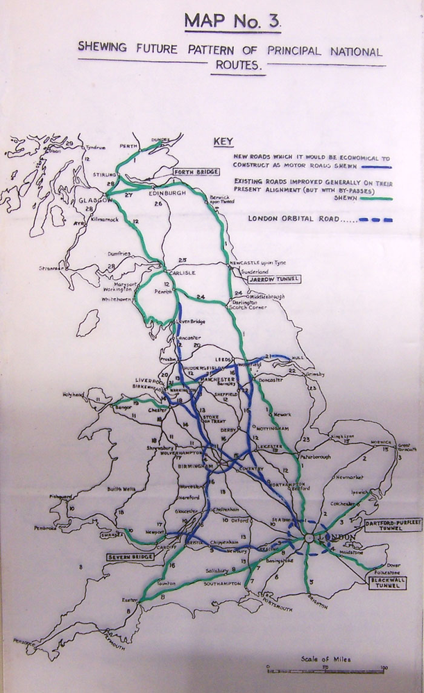
In 1942 the Ministry of Transport created the first official proposals for a motorway network across Britain. In May 1942, the Hollinghurst Report demonstrated the need for new high-speed roads for transporting goods around the country. A small number of routes are intended to connect the main centres of industrial activity to the ports, and whose routes were chosen to relieve the trunk routes where on-line improvement would be most difficult. Five new roads merit consideration as part of the future highway system;
1. London to Birmingham, Lancashire and Scotland, relieving the industrial backbone of the country which is today consistently heavily trafficked.
2. A branch from the first route, beginning at Coventry and reaching Leeds. This route would serve the East Midlands and Yorkshire, and provide them with access to London.
3. An extension of the Liverpool-East Lancashire Road (A580) across the Pennines to Yorkshire, to Leeds and possibly also to Hull.
4. A ring around Birmingham and the Black Country. The first proposal would pass to the north-east of the urban area so this route would complete the circle around the west and south.
5. Birmingham to Bristol, which would complete the links between the west coast ports from Glasgow to the Severn.
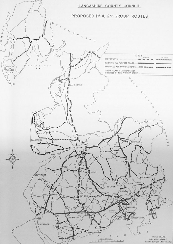
Lancashire County Council is very keen on these proposals and has already received permission, and is only waiting for funding to start work on the north-south motorway. In 1943 the Council drew up revised plans for the first section of the road, which is to be a bypass for Preston, running to the south and east of the town. Its layout and junction designs owe a great deal to the German Autobahn network. The Bypass scheme includes a road across the south of Preston linking to the A59 towards Liverpool, its course at the southern end was different, passing west of Walton-le-Dale and terminating on the A582 at Bamber Bridge, close to the junction of A6 and A49. At its northern end, designs have been prepared for a short spur at Broughton to be continued to Blackpool.
The country's civil engineers are also working to decide what form a British motorway might take. The Institution of Automobile Engineers published a joint report with a number of other bodies that suggested a design speed of 75mph, with 1ft (30cm) marginal strips at each side of each carriageway, and lanes 11ft (3.3m) wide on two-lane carriageways and just 10ft (3m) wide on three-lane carriageways. They also recommended parking places where drivers could rest, preferably located at viewpoints.
In 1942 the Ministry of Transport announced a ten-year investment programme in the road network. Among the small bypasses and widening schemes was the Preston Bypass and the Lancaster Bypass.
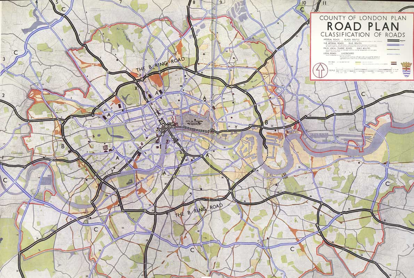
The County Of London Plan 1941
The London County Council tasked J.H. Forshaw, its resident architect, and Patrick Abercrombie to draw up a comprehensive plan for the County of London. The authors saw London's four "major defects" as traffic congestion, depressed housing, inadequacy and maldistribution of open spaces, and the jumble of houses and industry ("indeterminate zoning").
The road plan they created has three classifications of road:
Arterial Roads, without any frontages or access to side streets, and with parallel service roads
Sub-Arterial Roads, main roads in the built-up area, with frontage development permitted, but with service roads provided wherever possible and side streets blocked off
Local Roads, which cover all other urban roads.
All through traffic would be directed onto a network of arterial roads. Areas within the grid would be as self-contained as possible, to reduce the demand for travel. For the first time, the plan hinged on a system of ring roads - most importantly the B-Ring.
Arterials and Sub-Arterials
Roads in the plan were identified with letters and numbers; each ring road moving out from the central area received a letter (A-Ring, B-Ring" etc.); most radial routes were numbered. The arterial roads planned are:
1. The B-Ring, the principal ring road around central London, built for fast traffic. To be fully grade-separated. From the NW corner this follows the Westway to Ladbroke Grove, then cuts across in a straight line to Royal Oak, turn NE to Warwick Avenue, Lord's Cricket Ground, then along Prince Albert Road (meeting radial X), across Camden Town to Agar Grove, then through Barnsbury to Highbury Corner. It would turn ESE here through De Beauvoir Town, to the SW side of Victoria Park, then following the canal and the A1205 through Mile End to Limehouse (meeting radial Y). The road thens proceed down the western side of the Isle of Dogs, into a tunnel and emerging at Evelyn Street on the south bank of the Thames. From here, it follows a straight line to Queens Road (Peckham) station, then follows the railway line through Denmark Hill to Brixton. From Brixton, the road would lead to Clapham Common, taking the north side, then turning northwards along the A3220 to Battersea Park Road, and follow the West London Line back to the start.
2. Route X, the old north-south cross route proposed by the Royal Commission. Connecting radial 5 at Swiss Cottage with radials 16 and 19 at the Elephant, using Waterloo Bridge. It passes along Adelaide Road to Chalk Farm, there turning south-east to follow the railway line, and then the A400 (Hampstead Road) to Warren Street station. Here it tunnels under the A ring (Euston Road) and Bloomsbury to emerge just south of High Holborn. From here it heads south to use Waterloo Bridge, and then proceedsto Elephant and Castle.
3. Route Y, the Royal Commission's east-west cross route. This connects radial 13 at Limehouse with the B ring at Battersea Bridge. The route would be along the current A1203 (The Highway and East Smithfield), Thames Street, Embankment. It then tunnels under Whitehall and St James's Park to emerge at Ebury Street, then goes via Royal Hospital Road to join the Chelsea Embankment.
4. The main radial roads, all of which would have a junction with the B ring.
The sub-arterial roads planed are:
1.The A-Ring (the Inner Ring Road), which links the major railway termini, and formed "the boundary of the Empire, cultural and commercial core of London". There were to be sections in tunnel under Hyde Park and under the Thames east of Tower Bridge.
2.The C-Ring, effectively the North and South Circular Roads. It follows a route proposed by Bressey and Lutyens in 1934 but with a modification to prevent the demolition of a swathe of Hammersmith and Fulham. The Woolwich Ferry would be replaced with either a bridge or a tunnel.
3. Other radials and some connecting roads.
The Greater London Plan 1942
The second London Plan deals with the wider area, and was written by Abercrombie alone. For the area outside the County of London, he proposes three ring roads, one of which has already been detailed in the 1941 report.
1. The C-Ring would again be sub-arterial, following the line of the already extant North Circular Road, and adding its complement in the south.
2. The D-Ring, an express-arterial, and almost entirely a new route. This is intended to "girdle the general limits of the built-up area in London", in conjunction with the Green Belt. Starting from the west, its alignment is similar to A312 up to Northolt. Then it proceeds to Ruislip, Pinner Green, Bushey Heath, joining the Barnet Bypass at Well End and then to Waltham Cross. Here it turns SE, and is carefully routed across Epping Forest to pass between Loughton and Buckhurst Hill to reach Chigwell. From here, it follows the west side of Hainault Forest, then passes between Chadwell Heath and Romford to a proposed Dartford Tunnel. South of the river, the D-Ring heads to Swanley, then turns west via Chelsfield and, skirting Selsdon and Sanderstead, will be carried on an 80 ft viaduct from the Purley Downs towards Croydon Airport. Then between Ewell and Epsom to Hook, through Esher and crossing the Thames on a new bridge from Walton to Sunbury.
3. The E-Ring, another sub-arterial, is a revised version of the North and South Orbital Roads. This would be a parkway, with frequent laybys and picnic areas. The E-Ring does not join up across the Thames.
4. Ten principal radial routes, of express-arterial standard which are to motorway standard. Abercrombie's proposals for the motorway routes are:
1. London to Exeter and Plymouth via Chertsey (A4, A316 and what is the M3 in the National Plan.
2. London to South Wales via a proposed Severn Bridge. Begins as two spurs at London End, one from Sunbury (route 1 / D ring) and one from Duke's Wood (route 3), meeting at Lake End. Then as M4 in the National Plan.
3. London to Gloucester and Cheltenham. The A40 Western Ave, then passing just north of Marlow. Then Reading, Oxford, Gloucester. This is part of the M40 in the National Plan.
4. London to Birmingham. From Paddington to Harrow via the A404. Then along the LMS (Chiltern) line through Sudbury. Meets the D-Ring at Pinner Farm, and strikes out to meet the E-Ring at Chandler's Cross. Then up to Birmingham and Carlisle. This route is broadly similar to the M6 in the National Plan.
5. London to Newcastle and Edinburgh via St Albans. From the B-ring west of Camden Town, up to Haverstock Hill, with a three-mile tunnel beneath Hampstead Heath, rising by East Finchley station, following the eastern boundary of Islington Cemetery up to the North Circular. Then through Friern Barnet, meeting the D-Ring at Dancers Hill, and the following the A1 north.
6. London to Cambridge. Across Tottenham, joining the North Circular. Northwards to follow a line up the Lea Valley, then swings eastwards to join the M11 planned in the National Plan.
7. London to East Anglia via Chelmsford and Ipswich. Passes between Woodford and Wanstead, out east past Havering atte-Bower, to run parallel with the A12.
8. London to Canterbury and Thanet via Swanley, Meopham and Faversham. From B-Ring out to Catford, then the railway to Bromley and Swanley. Follows current line of A20 until Farningham, where it then leads to Meopham and Cuxton, crossing the Medway. Onwards to Faversham, then splitting to Canterbury and Margate. Boradly the M2 as planned under the National Plan.
9. London to South Coast Resorts (Brighton and Eastbourne) via Coulsdon and Horley. Follows the A3 to Clapham Common, then turning southwards, avoiding Tooting Common, then to the A23. Bifurcation at Horley; one branch follows the A23 to Brighton;, the other other striking across to the A22 and bypassing East Grinstead and Forest Row.
10. London to South Coast and Portsmouth via Stoke d'Abernon. Equivalent to A3, but Kingston Bypass not used (too many frontages to convert to motorway standard) and Guildford bypassed to the East.
Quoted
Originally posted by Hood

