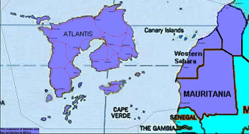
*Maps added to 3rd post* (Thanks to Walter and Shin!)
Basic info
Country name:
conventional long form: The Atlantian Empire or Atlantean Empire
conventional short form: Atlantis
abbreviation: AE
Government type:
confederation with constitutional monarchy
Capital:
Cleito
Nationality:
noun: Atlantean(s)
adjective: Atlantean
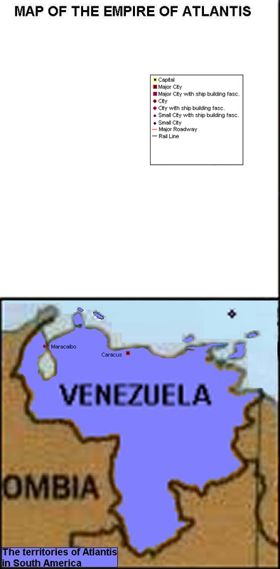
Dependent areas:
Autochthon (southern Morroco/western Algeria),Canary islands, Cape Verde islands, Grenada, Mauritania, Trinidad and Tobago, Venezuela(including Aruba, Curacao and Bonaire, Western Sahara
Population:................1921 figures........1928 figures..........1942 figures
Atlantis .......................56.3 million..........62.8 million............76.2 million
Venezuela ...................3.1 million............3.27 million............3.9 million
Autochthon ...............3.4 million.............3.595 million
Mauritania ..................650,000...............675,000
Canary Islands.............425,000................449,000
Trinidad and Tobago ...525,000...............555,000
Cape Verde Islands .....185,000...............195,000
Western Sahara...........125,000..............132,100
Grenada.....................87,800................92,800
Aruba.........................35,000................37,000
Bonaire.........................32,000...............33,800
Curacao.......................31,000................32,700
Total:.........................64,894,800.........71,867,400
Average population increase
Atlantis: 1.4%
Venezuela: 1.3%
Autochthon 0.8%
Mauritania 0.8%
Canary Islands: 0.8%
Trinidad and Tobago: 0.8%
Cape Verde Islands: 0.8%
Grenada: 0.8%
Aruba: 0.8%
Bonita: 0.8%
Curacao: 0.8%
Background:
Geography
Location:
Atlantic, continent in the Mid Atlantic Ocean, west of Mauritania, east of Cuba
Geographic coordinates:
0 0 N, 0 0 W
Area:
total: sq km
water: sq km
land: sq km
Area - comparative:
Greenland
Land boundaries:
0 km
Coastline:
0 km
Climate:
temperate; clear, hot summers in interior, more moderate and cloudy along coast; cloudy, cold winters in interior, partly cloudy and cool along coast
Terrain:
vast central plain, Metuendus mountains in north, hills and low Pepherdo mountains in east; rugged Tullus mountains and broad river valleys in the south east; rugged, volcanic topography in eastern region, with some steep, rugged, rocky, volcanic
Elevation extremes:
lowest point: Atlantic Ocean 0 m
highest point: Mount Atlas, Metuendus mountain range 6,234 m
Natural resources:
Nickel, Platinum, Orichalcum (high grade copper) Tin, Uranium, Phospates, Diamonds, Iron ore, Bauxite, Aragonite, Salt, Basalt rock, Limestone, timber, arable land
Land use:
arable land: 0%
permanent crops: 0%
other: 0%
Irrigated land:
NA sq km
Natural hazards:
seasonal harmattan wind produces obscuring dust on the east coast; volcanically and seismically active, tropical cyclones (hurricanes) develop off the coast of Africa near Cape Verde and move westward into the Caribbean Sea; hurricanes can occur from May to December, but are most frequent from August to November
Social and political
National holiday:
Anthesteria Feb. 26th to March 12
National symbol:
Labrys (double headed axe)
Constitution:
Languages:
Aquitainian, English (mainland), Euskara ( Cape Verde and Western Sahara) and Berberish ( Maritania )
Legal system:
based on English common law;
Executive branch:
chief of state: His/her magesty the King and Queen
head of government: Prime minister
Political parties:
Taurus party (conservatives), Elephus party (moderate conservatives),Falco party (moderate Liberals) Delpin party (liberals)
International organization participation:
CT(Cleito treaty, naval limitations treaty), FAR (France/Atlantis/Russia alliance), KKT (Kum Kale Treaty, with Turkey)NATO treaty (U.S., Britain, Canada, Australia, Mexico)
Flag description:
red with a black bull in the center and a gold Trident in the upper left hand corner.
Military info
Army peacetime strength: roughly 1,350,000 (as of 1936)
Navy strength: TBD