Dear visitor, welcome to WesWorld.
If this is your first visit here, please read the Help. It explains in detail how this page works.
To use all features of this page, you should consider registering.
Please use the registration form, to register here or read more information about the registration process.
If you are already registered, please login here.
So the only are that's Byzantine is the area around Istanbul? BTW, is it Istanbul or Constantinople?
Same borders except Istambul has been split in half. The eastern side is Turkish Istambul while the western half is constantinople. The remainder of the old Atlantean mandate is Byzantine.
OK, bit confused. From the sounds of it, the only area thats the Byzantine Republic is the immediate area of Constantinople since the area west of the straits in Europe is now Turkish as is the eastern part around Istanbul.
Nope, nearly the same borders except the eastern shore of Istambul is Turkish.


Like this?
Looks good to me. I wouldn't bother with the Istambul/Constantinople tag...the two are too close to each other.
Gah, it's the El Paso of the asshole of the world!

Been a long time gone, Constantinople. Why'd Constantinople get the works?
Its the makup of the geography really. Its basically a 60/40 split. The benifit for Turkey is the much more modern shipyards being built on the Turkish side to replace the old ones now in Byzantean control.
.....and depending on your sence of dirrection, the Greeks or the Russians may take offence to the asshole of the world comment!
If you have time and desire, could you please draw Formosa as province of China?
Kind regards and thanks a lot
There probably needs to be an update of South America as well in the post Chilean-Bolivian War. Bolivia seems to have been cut up three ways from Sunday and part of Chiile and been returned to Peru. In additon the disputed Chaco may come up again if the conflict around Paraguay/Uruguay gets to the point where Chile has to get involved.
I'll try and get to updating the map ASAP. As for South America, I've been waiting for the dust to settle before trying to make sense of it. At least I can relate to the people at Rand McNally back in the early 90's!

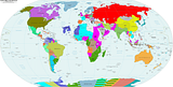
OK, this is the latest version of the Big Ass Map that I have. Its now several years out of date, so I'll need to have details on what needs to be updated.
Tacna province is part of Peru now instead of Chile.
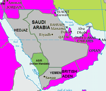
Asir is part of Hedjaz.
Pakistan is divided: The east is now part of India and Baluchistan is an "independent" nation, with British and Indian patronage.
This post has been edited 1 times, last edit by "perdedor99" (Sep 14th 2010, 2:37am)
This thread has the original map as well as the updated to 1938 map.
Originally posted by perdedor99
Tacna province is part of Peru now instead of Chile.
Asir is part of Hedjaz.
Pakistan is divided: The east is now part of India and Baluchistan is an "independent" nation, with British and Indian patronage.
You forgot to note that southern Bolivia is occupied by Chile.
There is also the eastern bit of Peru that is (unless minds have changed) now part of Colombia. The Colombian border at the south-eastern tip near Leticia simply continues down till the Brazilian border.
Originally posted by thesmilingassassin
There is also the eastern bit of Peru that is (unless minds have changed) now part of Colombia. The Colombian border at the south-eastern tip near Leticia simply continues down till the Brazilian border.
If memory serves, the deal was that section of northeastern Peru would be demilitarized, but the borders wouldn't change. (That's to your advantage anyway, quite frankly, as it's easier to patrol a river border than a line through the jungle.)
The preposed demilitarized zone was everything north of the Rio de Amazonas from the pre-existing border near Leticia to Equador. That wouldn't change much from the pre war position of the Peruvians, Iquitos would still have a large airbase but no further bases would be build in that region.
Chile has no opinion on the demilitarized zones, but Chile will not support altering the borders.
The borders of Aden and the SW corner of Arabia need amending to.
Quoted
Originally posted by perdedor99