This post has been edited 1 times, last edit by "parador" (Dec 21st 2010, 12:50am)

Quoted
Originally posted by Rooijen10
Uhm... Probably rescueing people?
Quick search with google got me to this, which I believe is what parador may have in mind.
http://www.lonesentry.com/articles/ttt07/rescue-buoy.html
Originally posted by Rooijen10
Uhm... Probably rescueing people?
Quick search with google got me to this, which I believe is what parador may have in mind.
http://www.lonesentry.com/articles/ttt07/rescue-buoy.html
Originally posted by Brockpaine
Originally posted by Rooijen10
Uhm... Probably rescueing people?
Quick search with google got me to this, which I believe is what parador may have in mind.
http://www.lonesentry.com/articles/ttt07/rescue-buoy.html
I didn't see this posted. But the image in your link helps a lot in demonstrating what it is.
Interesting little device.
 . Good to know, that's now clear.
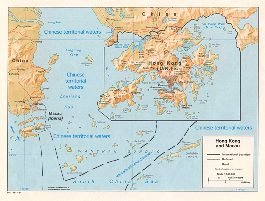
Dear Ladies and gentlemen, all ambassadors of the LoN,
territorial waters, as defined, are a belt of coastal waters from the baseline (usually the mean low-water mark) of the coast.
The territorial water is regarded as the sovereign territory of the state, although foreign ships (civilian) are allowed innocent
passage through it; this sovereignty also extends to the airspace over and seabed below.
With 1st August, China declares a 12-Mile-Zone of territorial waters around the coast of China. With this step, China follows
the general approach to extend the territorial waters. Due to its geographical location, Hong Kong and Macao would now re-
present enclaves inside chinese territory. To further ensure the freedom of navigation to and from Hong Kong and Macao,
China come to the subsequent agreement with Great Britain (Great Britain represents here the interests of Iberia).
Agreement about the situation of Hongkong & Macao in the chinese territorial waters:
To ensure the free shipping to and from Hong Kong & Macao, China undertakes to establish a minimum 3-5 miles wide international corridor.
This corridor is called "The International Lema Channel". This corridor is determined according to the illustrated map. The corridor
is marked with the followed buoys: bright green on the western side, and bright red on the eastern side of the corridor.
[size=1]The map of the agreement[/size]
In this corridor, any hostile or military operation is prohibited. This corridor is to be used by all ships, whether civilian or military,
who wants to travel to and from Hongkong also who wants to travel to and from Macao. It is prohibited for the chinese navy, to stop a vessel,
which is using the corridor.
Submarines and all other underwater vehicles, which are using this corricor, have to travel surfaced and have to show their flag.
Ships of any nation that are encountered outside the corridor, could be stopped and investigated at any time by chinese authorities or
armed forces.
This Agreement comes into force with the chinese declaration of the 12-Mile-Zone of territorial waters on 1.August 1940 and is valid until
the end of the lease of the New Territories.
The Agreement is signed by
the Governor of Hong Kong as represent of Great Britain
and
His Imperial Majesty the Emperor of the Great Quing Dynasty, Son of Heaven, Lord of Ten Thousand Years Aisin Gioro Pu Yi
Forum Software: Burning Board® Lite 2.1.2 pl 1, developed by WoltLab® GmbH